Home > News > New paper in Journal of Applied Earth Observations and Geoinformation by Yolanda Torres et al.
New paper in Journal of Applied Earth Observations and Geoinformation by Yolanda Torres et al.
The paper present a procedure for assessing the urban exposure and seismic vulnerability that integrates LiDAR data with aerial images from the Spanish National Plan of Aerial Orthophotography (PNOA).
27/05/2019
We apply the procedure to 826 buildings in the city of Lorca (SE Spain), where we count on a vulnerability database that we use as ground truth for the validation of results. The outcomes show that the machine learning techniques have similar performance, yielding vulnerability classification results with an accuracy of 77%–80% (F1-Score).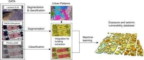
The procedure is scalable and can be replicated in different areas. This is particularly relevant in Spain, where more than seven hundred towns have to develop seismic risk studies in the years to come, according to the General Direction of Civil Protection and Emergencies. It is especially interesting as a complement to conventional data gathering approaches for disaster risk applications in cities where field surveys need to be restricted to certain areas, dates or budget.
For read the full article click here: